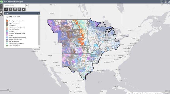
The Nature Conservancy has publicly released a map to help companies and communities identify the most promising places in the central U.S. to quickly develop renewable energy while avoiding impacts to important wildlife and habitats.
Called Site Renewables Right, the new analysis combines more than 100 GIS layers of wildlife habitat and land use data, helping to find areas where renewable energy development is most likely to avoid important natural areas, permitting delays, and cost overruns.
This first-of-its-kind map puts the latest research and data on the best places to source renewable energy in the hands of companies and communities. The Site Renewables Right map spans 19 states, from Ohio to Wyoming.
All told, Site Renewables Right estimates at least 120,000 square miles, an area larger than Arizona, hold the potential for low-conflict renewable energy siting in the central United States. The analysis suggests these areas could support approximately 1,000 GW of wind capacity – nearly 10 times the current U.S. wind capacity.
“To tackle climate change, we need to transition to renewable energy, and fast. Site Renewables Right finds there is huge opportunity to do this at a large-scale across the central United States, without significant impacts to habitat and wildlife,” says Nathan Cummins, director of renewable energy programs for The Nature Conservancy’s Great Plains Division. “Like any type of development, solar and wind facilities can harm wildlife and habitat if not sited properly. Site Renewables Right provides a way for companies and communities to assess those impacts. It encourages the right conversations to avoid project delays and impacts to the very same wildlife and natural areas we are trying to protect from climate change.”
Identifying low-conflict places for renewable energy in the region is critical, as the central United States is home to North America’s largest and most intact temperate grasslands, among the most altered and least-protected habitats in the world. It is “home on the range” for iconic wildlife such as bison, eagles, pronghorn, deer, and prairie chickens.
“Renewable energy and transmission are critical to reducing emissions and slowing global temperature rise to ensure a cleaner future for both people and wildlife,” states Garry George, director of the Clean Energy Initiative at National Audubon Society. “The Site Renewables Right tool plays an important role in Audubon’s analysis of clean energy planning and individual projects to make sure that conservation and renewables go hand-in-hand.”
With up to 75% of the nation’s large renewable energy projects expected to be developed in the 19-state region by 2050, tools such as Site Renewables Right can help companies, state agencies and communities quickly plan, permit and purchase renewable energy in ways that helps conserve natural areas.
Companies can use Site Renewables Right to meet their climate goals and support wildlife conservation at the same time.
“The Nature Conservancy’s Site Renewables Right map is an excellent example of data capture that helps organizations make informed business decisions when evaluating renewable energy projects,” comments Roberta Barbiera, VP of global sustainability at PepsiCo. “Projects that are properly sited and developed support a sustainable and equitable clean energy transition, a critical lever in achieving our net-zero by 2040 goal and broader pep+ (PepsiCo Positive) ambitions.”
Energy companies are embracing this technology as well to help them achieve climate targets.
“Renewable energy plays a critical role in Xcel Energy’s vision to deliver at least 80% emissions reduction by 2030, and we’re responsibly developing wind and solar resources to protect the environment,” mentions Jeff West, senior director of environmental at Xcel Energy. “We’re committed to working with organizations such as The Nature Conservancy and its Site Renewables Right initiative that researches and supports protecting wildlife and other natural resources as we provide a clean energy future for our customers.”


