Wind is a sustainable and renewable energy source, so we will continue to see more and more wind turbines dotting our landscape as we harness this power for our energy. Developers must consider many restrictions and constraints, including wind characteristics in the area, land availability, existing buildings and infrastructure, protected species and lands, Federal Aviation Administration (FAA) and Department of Defense (DOD) clearance, and geographical landscape surrounding proposed locations.
Visual inspections of individual sites, a process called micrositing, must be completed before a wind turbine and its associated infrastructure’s site can be chosen. Micrositing is critical to maximizing a turbine’s efficiency and to identifying potential obstacles when placing turbines.
The geographical landscape can be a complicated consideration when determining a potential wind turbine site. Wind turbines contain many components, and long, oversized vehicles are used to deliver these components to each site. The delivery vehicles require large areas to make turning movements and cannot traverse steep terrain or negotiate roads that have quick changes in terrain.
Further, large cranes are needed to erect the components required to construct the wind turbine. It is best to move the cranes, fully assembled, from one wind turbine site to the next to help control costs and save time. This process requires additional planning.
To allow for large delivery vehicles and to optimize the crane route, civil engineers lay out access roads to each individual wind turbine site during preliminary design. The preliminary design is typically created using high-resolution aerial imagery data and aerial topographic survey data to illustrate the geographical landscape. Many visible features such as drainage patterns, tree masses or other physical restrictions can be identified from this remotely obtained data.
After the preliminary access road design is completed, engineers usually conduct an in-person field review as part of micrositing. During the field review, each wind turbine site is examined more closely for areas that must be avoided or modified to allow for site access by large delivery vehicles.
Some sites can be seen from existing roads, and the design can be verified quickly. But many sites aren’t visible from existing roads, and, even further, some sites can’t be reached easily even by all-terrain vehicles.
In those cases, the project engineers must verify the proposed delivery route on foot. Between walking and driving, engineers can review 25-30 sites per day, but utility-scale wind farms are expanding and are generally made up of more than 100 wind turbine sites. Depending upon project size, the micrositing process can become inefficient in both time and cost.
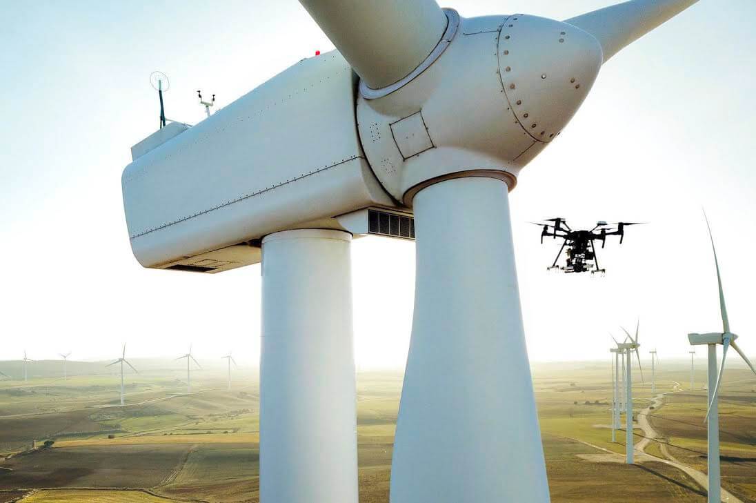
One solution for reducing time and costs associated with the micrositing process is to use an unmanned aerial vehicle (UAV) when conducting the in-person field review. A single UAV operated by one pilot can review more than 100 sites in a day.
The UAV provides live, real-time, high-resolution video to the developer’s project team. This video can easily be viewed on monitors in the field or livestreamed to team members in the home office. The visual feed from the UAV in the field and the proposed access road design plans can be placed side by side to understand the geographic landscape in real time.
If different areas along a proposed access route must be examined further or changed during the review, the project team has direct communication with the UAV pilot, who can react immediately and modify the UAV flight plan to include additional areas for review. The data is recorded and stored so information from the micrositing is available at any time to reference and use.
Case study
Mike Laird is a senior surveyor in Olsson’s Overland Park, Kan., office and has logged hundreds of hours in the cockpit as a private pilot. UAV experts like Laird combine their piloting skills with computer networking and global positioning system (GPS) technology to produce dramatic results in micrositing field data, in real time.
We recently gathered several clients and ran tests of our micrositing process to demonstrate the geographic precision that can be achieved with UAVs. Laird uses a specialized UAV that can handle wind gusts of up to 45 mph – a requirement for proposed wind energy sites.
Rather than climbing on ATVs, clients sat comfortably in a sport utility vehicle (SUV) while the UAV flew from proposed site to proposed site. Inside the vehicle, clients watched a livestream of each site inspection, noting the location of every fence, irrigation system, utility pole, oil well, livestock feeder or other potential obstacle. Clients were able to input changes to the proposed site plan directly into their laptops, which reduces the need for future design adjustments.
Rather than conducting the standard three dozen site assessments in a day, one pilot was able to complete more than 100.
Another micrositing tool is a terrestrial light detection and ranging (lidar) scanner. Lidar scanning with UAVs offers an alternative way to capture and create high-definition, 3D models or computer-aided design (CAD) drawings of any object or space using multiple scans from different vantage points to create a dense point cloud.
Compared to traditional surveying methods for topography and contours, UAV lidar scanning services create 3D models much faster and with a higher level of detail, providing survey documents that capture up to 100,000 points per second at 3-mm accuracy. This equipment can be used in all light levels, including total darkness. High- resolution imagery is also acquired during the UAV flight, from which a virtual “fly-through” can be generated.
No other technology can produce detailed, high-definition 3D surface models like those obtained through lidar scanning. A lidar scanner can obtain measurements in a 360-degree horizontal motion and a 270-degree vertical motion.
The extensive amount of data acquired using this equipment has cut back on and/or eliminated the previous need for additional field visits. Lidar scanning can also reduce the number of project change orders that happen when actual site conditions differ from design plans, providing a time and cost savings.
Rod Hanson is with Olsson, an engineering and design firm that serves a number of markets, including onshore and offshore wind.
Photo courtesy of Sulzer Schmid, the leading UAV technology experts for rotor blade inspections


